
Short Answer
Location
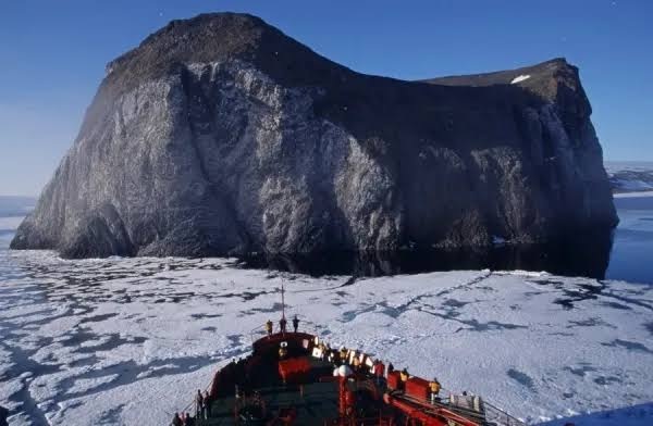
Rubini Rock rises on the western coast of Hooker Island, one of the central islands of the Franz Josef Land archipelago (Russia). The cliff is situated at approximately 81°30′ N latitude and 56°30′ E longitude, overlooking the ice‑filled Tichaia Bay. Its position makes it a natural landmark for vessels navigating the Queen Victoria Sea.
Map
Modern Russian hydrographic charts (scale 1:200 000) and satellite imagery from the Copernicus programme display Rubini Rock as a dark, jagged outcrop against the surrounding ice caps. Historical British charts from the 1880 s also mark the feature, confirming its visibility to early explorers.
Geography
Hooker Island covers roughly 507 km² and is dominated by the Kupol and Vostok ice caps, which together blanket about 85 % of the land. The island’s coastline is deeply indented, with several sheltered bays; Tichaia Bay lies directly east of Rubini Rock and provides the most accessible landing site for researchers and tourists. The cliff itself rises about 120 m above sea level and forms a sheer basalt wall that drops directly into the bay.
Glaciers
The island’s glacial system is typical of central Franz Josef Land, where cold‑based glaciers dominate. The most significant ice masses are:
| Glacier | Area (km²) | Terminus |
|---|---|---|
| Kupol Ice Cap | 210 | Eastern shoreline, feeds Tichaia Bay |
| Vostok Glacier | 95 | North‑west coast |
| Poliakov Glacier | 45 | South‑west flank |
All three are retreating at a rate of 5–10 m per year, a trend documented by the Russian Academy of Sciences since the 1990s.
Geology
Rubini Rock is a classic example of columnar basalt, formed when thick lava flows cooled rapidly, fracturing into polygonal columns. The basaltic suite of Hooker Island belongs to the Late Cretaceous to early Paleogene volcanic province that underlies much of Franz Josef Land. Petrographic analysis shows a predominance of olivine‑rich tholeiitic basalts, similar to those found on neighboring Zichy and Bell Islands.
Wildlife
The basalt cliffs provide ideal nesting ledges for several Arctic seabird species. Long‑term monitoring (2000‑2023) records breeding populations of:
- Thick‑billed Murre (Uria lomvia) – ~15,000 pairs
- Brünnich’s Guillemot (Uria lomvia) – ~9,000 pairs
- Black‑legged Kittiwake (Rissa tridactyla) – ~12,500 pairs
Polar bears (Ursus maritimus) and ringed seals (Pusa hispida) are regular visitors to the ice‑covered waters of Tichaia Bay, while occasional walrus haul‑outs occur on the lower slopes of the cliff.
Exploration History
Rubini Rock was first documented by British explorer Benjamin Leigh Smith during his 1880 expedition to the high Arctic. Smith’s ship, the Hope, anchored in Tichaia Bay, and his party climbed the basalt face to obtain a panoramic survey of the surrounding islands. The feature was later referenced in the reports of the Jackson‑Harmsworth Polar Expedition (1894‑1897) and served as a visual checkpoint for the 1903‑1905 Fiala‑Ziegler Polar Expedition.
Historic Sites
Remnants of Leigh Smith’s temporary field camp are still visible near the base of Rubini Rock. Stone foundations and a few rusted metal tools have been recorded by Russian archaeologists in 2018. No permanent structures exist, but the site is protected under Russian heritage law as part of the Franz Josef Land National Nature Reserve.
Scientific Research
Since the early 2000s, Rubini Rock has been a focal point for avian ecology studies conducted by the Russian Arctic Institute and the Norwegian Polar Institute. Researchers use the cliff to monitor breeding success, phenology and the impacts of sea‑ice decline on seabird foraging. In addition, the basalt provides a natural laboratory for studying weathering processes in extreme cold, with recent papers examining carbonate precipitation on the rock surface.
Name Origin
The designation “Rubini Rock” appears in 19th‑century British expedition logs, but the precise eponym is not recorded in the surviving documents. It is widely believed to honour an Italian patron or scientist associated with the era’s polar ventures, although definitive archival evidence is lacking.
Related Islands
Rubini Rock lies within a cluster of historically and ecologically significant islands:
- Northbrook Island – site of Cape Flora, the 1881 shipwreck of Benjamin Leigh Smith.
- Jackson Island – home to Cape Norway, the 1895‑96 wintering hut of Fridtjof Nansen and Hjalmar Johansen.
- Alexandra Land – location of the Russian military base Nagurskoye.
- Rudolph Island – northernmost Eurasian landmass, containing the world’s most northerly weather station.
- Bell Island – features a bell‑shaped mountain and a preserved wooden lodge from Leigh Smith’s 1881 winter stay.
FAQ
Why is Rubini Rock important for seabirds?
The sheer basalt cliffs provide safe, predator‑free nesting ledges above sea level, supporting large colonies of thick‑billed murres, Brünnich’s guillemots and kittiwakes.
Can tourists visit Rubini Rock?
Access is possible via ice‑breaker cruises that anchor in Tichaia Bay; visits are regulated by the Russian nature reserve to minimise disturbance to wildlife.
What geological processes created Rubini Rock?
Rubini Rock formed from Late Cretaceous basaltic lava flows that cooled rapidly, producing columnar jointing characteristic of basalt cliffs.



Leave a Reply