

Short Answer
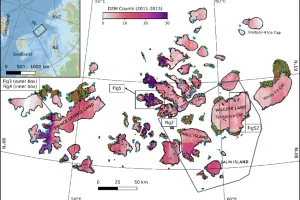
Franz Josef Land lies deep within the Arctic Ocean at roughly 81° N, 55° E. The archipelago consists of about 192 islands that together span 16,134 km² (6,229 sq mi) and stretch 375 km east‑west. Roughly 85 % of this area is covered by ice, making it one of the most heavily glaciated landmasses on Earth. Understanding why so many glaciers exist here requires a synthesis of climate, precipitation, topography, and geology, all of which have been documented since the first Austro‑Hungarian discovery in 1873.
Study Area
The islands sit at the northernmost edge of the Eurasian continental shelf, bordering the Barents Sea and the Arctic Ocean. The highest point, 620 m on Wiener Neustadt Island, is modest, but the islands are deeply dissected, producing a coastline‑to‑area ratio of only ~3.6 km² per kilometre of shore. This fragmentation creates numerous sheltered valleys where snow can accumulate and compact into ice. Administratively the archipelago belongs to Arkhangelsk Oblast and has been part of the Russian Arctic National Park since 2012.
What Scientists Measure
Glaciological research in Franz Josef Land focuses on several key parameters:
- Ice extent and area: Satellite imagery (Landsat, Sentinel‑2, MODIS) provides yearly maps of glacier outlines.
- Surface elevation and volume: Airborne laser altimetry (ICESat‑2) and radar interferometry (CryoSat‑2) track changes in ice thickness.
- Mass balance: Stake networks and snow pits on selected ice caps record accumulation versus ablation.
- Flow velocity: Feature‑tracking of SAR (Synthetic Aperture Radar) images measures glacier motion.
- Sub‑glacial topography: Ground‑penetrating radar surveys reveal bedrock morphology that controls glacier dynamics.
- Climatic drivers: Automatic Weather Stations (AWS) record temperature, wind, precipitation, and radiation at sites such as the Ernst Krenkel Observatory on Hayes Island.
Historical Evidence
Early explorers noted the archipelago’s icy character. The Austro‑Hungarian North‑Pole Expedition (1872‑74) produced the first systematic maps, describing “continuous ice fields” on the larger islands. Nansen and Johansen, wintering at Cape Flora in 1895‑96, recorded daily snow depths of up to 1.5 m and observed that the surrounding sea was locked in pack ice for most of the year. Leigh Smith’s 1880 and 1881 voyages reported that only a few small coastal bays were ice‑free in summer, confirming a high glacial cover even in the late 19th century. These qualitative observations provide a baseline against which modern remote‑sensing data can be compared.
Recent Research
Since the 1990s, Russian and international teams have intensified monitoring. The Arctic and Antarctic Research Institute (AARI) operates several AWS and conducts annual field campaigns to measure glacier mass balance on the largest ice caps, such as the Karpinsky Ice Dome on Karpinsky Island. European projects under the International Polar Year (2007‑08) deployed GPS stations on outlet glaciers of Graham Bell Island, documenting flow speeds of 30–70 m yr⁻¹. More recently, the Russian‑German “Franz Josef Land Glaciology Initiative” (2020‑2024) has combined high‑resolution Sentinel‑1 interferometry with airborne radar sounding, producing the first three‑dimensional model of sub‑glacial basins across the central group.
| Year | Activity | Key Outcome |
|---|---|---|
| 1994 | Designation of nature sanctuary | Legal framework for scientific access |
| 2007‑08 | International Polar Year fieldwork | Installation of GPS and AWS on several glaciers |
| 2015 | ICESat‑2 elevation profiling | Detected average thinning of 0.4 m on major ice caps |
| 2022 | Sentinel‑1 SAR interferometry | Mapped retreat of outlet glaciers on Wilczek Land |
What Has Changed
Satellite records show that the total glaciated area has decreased modestly over the past three decades. Analyses of Landsat images from 1990 to 2020 indicate a net loss of roughly 2 % of glacier cover, primarily at the lower elevations of the western islands where summer melt is strongest. Ice‑cap thickness measurements from ICESat‑2 reveal an average thinning of 0.3–0.5 m on the largest domes, suggesting a negative mass balance driven by rising air temperatures (+0.6 °C per decade) and a slight reduction in winter snowfall. Nevertheless, the archipelago remains overwhelmingly ice‑dominated; even the most southerly outlet glaciers retain a thick, cold‑based ice core that is largely insulated from surface melt.
Uncertainty and Open Questions
Several knowledge gaps persist:
- Sub‑glacial hydrology: The extent of basal water systems and their influence on glacier sliding are poorly constrained.
- Snow accumulation patterns: Sparse AWS coverage leaves uncertainty about spatial variability in winter precipitation, which can differ by more than 30 % across short distances.
- Future climate scenarios: Model projections for the Barents Sea region vary, leading to divergent predictions for glacier response under continued warming.
- Ice‑ocean interaction: The role of warm Atlantic water incursions in accelerating terminus retreat of outlet glaciers is still being quantified.
Data Sources
Researchers draw on a suite of openly available and institutional datasets, including:
- Russian Academy of Sciences – AARI weather and glacier‑mass‑balance archives.
- NASA Earth Observing System – Landsat and ICESat‑2 products.
- European Space Agency – Sentinel‑1 SAR and Sentinel‑2 optical imagery.
- International Arctic System Study (IASS) – compiled climate indices for the Barents Sea.
- Russian Arctic National Park – protected‑area GIS layers and historic cartography.
These resources enable continuous monitoring of the archipelago’s ice cover and support comparative studies across the high Arctic.
FAQ
Why is the glaciation percentage so high compared with other Arctic archipelagos?
Franz Josef Land sits at a higher latitude, experiences colder year‑round temperatures, receives abundant maritime snowfall, and has a rugged, low‑relief topography that promotes ice accumulation and limits melt.
Do any glaciers on Franz Josef Land currently retreat?
Yes. Satellite observations since the 1990s show retreat of several outlet glaciers, especially on the western islands where summer melt is strongest, while the interior ice domes remain relatively stable.
How does the geology of the islands affect glacier formation?
The islands consist mainly of Jurassic–Cretaceous marine sediments overlain by basaltic and doleritic intrusions that create flat plateaus and gentle slopes, providing broad surfaces for snow accumulation and limiting erosion that would otherwise expose bedrock.

Leave a Reply