
Short Answer
Location
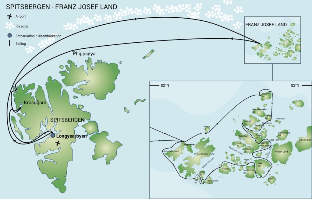
Austrian Strait (Russian: Австрийский пролив) lies at approximately 80°42′ N, 59°00′ E in the eastern sector of the Franz Josef Land archipelago, Arkhangelsk Oblast, Russia. The strait forms the boundary between the island group centred on Wilczek Land to the east and the islands of Wiener Neustadt and Hall to the west, opening northward into the Barents Sea.
Map
Modern nautical charts depict Austrian Strait as a north‑south oriented channel that begins at the Beryozkina Channel in the north, runs south‑southeast along the western shore of Wilczek Land, and terminates in the northeastern Barents Sea. Historical maps from the Austro‑Hungarian North Pole Expedition (1874) first recorded the waterway under the name “Austria‑Sund”.
Geography
The strait spans roughly 35 km in length and 8–12 km in width, though its exact dimensions vary seasonally with sea‑ice extent. It is bounded by steep, glacier‑carved cliffs on Wilczek Land and low, tundra‑covered coastlines on Wiener Neustadt Island and Hall Island. The channel is ice‑locked for most of the year, with a brief ice‑free period in late July and early August when limited navigation is possible.
Glaciers
Wilczek Land hosts the majority of the glacial mass bordering Austrian Strait. The following table lists the principal glaciers that terminate in or near the waterway:
| Glacier | Location | Length (km) | Terminus |
|---|---|---|---|
| Stremitelny Glacier | North‑west flank of Wilczek Land | 12 | Austrian Strait |
| Vavilov Glacier | Central Wilczek Land | 9 | Austrian Strait (southern sector) |
| Hall Glacier | Western coast of Hall Island | 4 | Austrian Strait (near Hall Island bay) |
Geology
The islands surrounding Austrian Strait are composed principally of Precambrian crystalline basement rocks overlain by Paleozoic sedimentary sequences. Wilczek Land exhibits extensive slate and quartzite formations, while Wiener Neustadt Island is characterized by Devonian limestone cliffs. The region has undergone multiple phases of glacial sculpting, producing U‑shaped valleys and fjord‑like inlets that define the strait’s present morphology.
Wildlife
Despite the harsh climate, the strait and its adjoining coasts support a modest but ecologically important assemblage of Arctic fauna:
- Marine mammals: Ringed seals (Pusa hispida) use the ice floes for pupping; occasional visits by walrus (Odobenus rosmarus) are recorded.
- Terrestrial mammals: Polar bears (Ursus maritimus) traverse the ice bridge between islands, especially during the spring melt.
- Birdlife: Thick‑billed murres (Uria lomvia) and black‑legged kittiwakes (Rissa tridactyla) breed on the cliffs of Hall Island.
- Vegetation: Sparse mosses, lichens, and dwarf willow (Salix herbacea) colonize ice‑free nunataks.
Exploration History
The Austro‑Hungarian North Pole Expedition (1872‑1874) under the command of Julius Payer and Karl Weyprecht penetrated the archipelago in the summer of 1874. On 1 April 1874, the party entered the newly discovered passage, naming it “Austria‑Sund” in honor of their sponsoring empire. The expedition’s reports provided the first reliable cartographic data for the eastern islands and the strait itself.1
Subsequent Russian Arctic surveys in the early 20th century refined the charting of the channel, and during the Soviet era the strait was used intermittently for ice‑breaker passages en route to research stations on Wilczek Land.
Historic Sites
Remnants of the 1874 Austro‑Hungarian expedition—primarily a modest cairn and a weather‑observing stone—remain on the western shore of Wilczek Land near the mouth of Stremitelny Glacier. These sites are protected under Russian heritage regulations and are occasionally visited by scientific parties.
Scientific Research
Modern research in Austrian Strait focuses on sea‑ice dynamics, glacier mass balance, and climate‑induced ecological change. The Russian Arctic and Antarctic Institute operates a seasonal monitoring station on Hall Island that records ice thickness, temperature, and oceanographic parameters throughout the brief summer window. Satellite‑based studies (e.g., Sentinel‑1 SAR) regularly monitor the strait’s ice cover to improve navigation safety and climate models.
Name Origin
The name “Austrian Strait” derives directly from the German term “Austria‑Sund,” bestowed by the Austro‑Hungarian North Pole Expedition after their homeland. The Russian translation “Австрийский пролив” preserves the original dedication.
Related Islands
The strait is flanked by several notable islands within Franz Josef Land:
- Wilczek Land – the easternmost large island forming the strait’s eastern bank.
- Wiener Neustadt Island – lies directly west of Wilczek Land, separated by the narrowest part of the channel.
- Hall Island – situated southwest of the strait, its western coastline meets the waterway near Hall Glacier.
- Zichy Island – located further north, visible from the strait’s northern entrance.
- Alexandra Land – part of the broader archipelago, lies to the northwest of the strait’s mouth.
FAQ
When was Austrian Strait first discovered and named?
The strait was first entered and named "Austria‑Sund" on 1 April 1874 by the Austro‑Hungarian North Pole Expedition led by Julius Payer.
Which islands border Austrian Strait?
Wilczek Land lies to the east, while Wiener Neustadt Island and Hall Island form the western and southwestern banks of the strait.
Is Austrian Strait navigable year‑round?
No. The strait is ice‑bound for most of the year; a narrow window of limited navigation exists during the brief Arctic summer (late July to early August).



Leave a Reply