
Short Answer
Glaciers covering roughly 80% of Franz Josef Land are divided into two principal terminus types. Land‑terminating glaciers end on exposed bedrock or moraine fields well inland, whereas marine‑terminating (tide‑water) glaciers discharge ice directly into the Barents Sea, often calving icebergs. The two classes respond differently to atmospheric warming, oceanic heat flux, and regional precipitation patterns, producing distinct signals in meltwater runoff and sediment flux.
Understanding the balance between these glacier types is essential for interpreting the archipelago’s contribution to Arctic hydrology, sea‑level rise, and the stability of its coastal ice cliffs. Over the past three decades, modelling and remote‑sensing studies have quantified climatic mass balance, runoff, and melt‑event frequency, revealing a nuanced picture of change that challenges the simplistic view of uniform glacier retreat.
Study Area
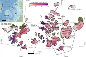
Franz Josef Land (Russian: Земля Франца‑Иосифа) lies between 80°30′ N–81°50′ N and 50°00′ E–65°00′ E in the Barents Sea, forming the northernmost extension of the Russian Arctic. The archipelago comprises about 190 islands, of which the larger ones—such as Rudolf Island, Hall Island, and Zemlya Georga—host the majority of the ice‑covered terrain. Glaciers range from small cirque ice caps to extensive outlet glaciers draining the central ice domes.
The region is administered as part of Arkhangelsk Oblast and is protected within the Russian Arctic National Park (established 2009). Scientific activity is coordinated by the Arctic and Antarctic Research Institute (AARI), the University of Oslo’s Cryosphere Centre, and the Norwegian Polar Institute, among others.
What Scientists Measure
Research on Franz Josef Land glaciers focuses on several key parameters:
- Climatic mass balance (CMB): the net gain or loss of ice due to snowfall versus surface melt, expressed in metres water equivalent per year (m w.e. a⁻¹).
- Ice‑discharge and runoff: volume of meltwater and iceberg calving reaching the ocean.
- Terminus position change: retreat or advance of the glacier front, measured with satellite imagery (Landsat, Sentinel‑2) and aerial photography.
- Surface velocity: derived from feature‑tracking of optical or SAR images.
Field measurements include stake networks for surface melt, GPS stations for ice motion, and automatic weather stations (AWS) that record temperature, precipitation, and radiation. The Ernst Krenkel Observatory on Hayes Island provides a long‑term AWS record and hosts a GNSS receiver used to monitor ice‑sheet uplift.
Historical Evidence
Early accounts from the Austro‑Hungarian North‑Pole Expedition (1872–73) and the Jackson–Harmsworth Expedition (1894–97) noted the presence of towering tide‑water glaciers along the western coasts of the archipelago, but quantitative data are absent. The first systematic glaciological observations were made by Soviet scientists in the 1930s, who recorded surface ablation on Shokal’ski Glacier (Novaya Zemlya) and noted a few land‑terminating outlet glaciers on Rudolf Island.
These sparse observations served as a baseline for later geodetic studies that employed satellite altimetry and gravimetry to estimate total mass change for the period 2000–2019. Those studies reported an overall negative mass balance of about –0.24 ± 0.16 m w.e. a⁻¹ for Franz Josef Land, indicating net loss when frontal ablation was included (Moholdt et al., 2012; Kochtitzky et al., 2021). However, the contribution of land‑terminating versus marine‑terminating glaciers could not be separated.
Recent Research
The most comprehensive recent effort is the CryoGrid modelling study by Schmidt et al. (2025), which simulated climatic mass balance for every glacier in Franz Josef Land and Novaya Zemlya at 2.5 km resolution using the Copernicus Arctic Regional Reanalysis (CARRA) forcing. The model provides separate runoff estimates for land‑terminating and marine‑terminating glaciers, revealing that marine‑terminating outlets dominate the meltwater export despite representing only ~30 % of glacier area.
Key results include:
- Average CMB for land‑terminating glaciers in Franz Josef Land: +0.21 m w.e. a⁻¹ (positive, indicating net accumulation) over 1991–2022.
- Average CMB for marine‑terminating glaciers: slightly lower, with occasional negative years linked to enhanced oceanic melt.
- Since 2010, the frequency of high‑melt years (>0.5 m w.e.) has increased, producing record runoff events in 2018 and 2021.
These findings are corroborated by satellite‑derived velocity increases for tide‑water glaciers observed by the European Space Agency’s Sentinel‑1 mission, which show acceleration of up to 30 % in the 2015–2022 interval.
What Has Changed
Combining model output with geodetic estimates yields a nuanced picture of change:
| Feature | 1991–2022 (model) | 2000–2019 (geodetic) |
|---|---|---|
| Overall CMB (Franz Josef Land) | +0.21 m w.e. a⁻¹ | –0.24 ± 0.16 m w.e. a⁻¹ |
| Frontal ablation (marine‑terminating) | –0.71 ± 0.33 m w.e. a⁻¹ | –0.71 ± 0.33 m w.e. a⁻¹ (Kochtitzky 2021) |
| High‑melt year frequency | Increased after 2010 (record years 2018, 2021) | Not quantified historically |
Thus, while the climatic mass balance of land‑terminating glaciers remains slightly positive, the overall mass budget of the archipelago is negative because marine‑terminating glaciers lose ice rapidly through calving and submarine melt. The intensified high‑melt years correspond to anomalously warm summer air temperatures (+2 °C above the 1991–2020 mean) and reduced sea‑ice cover, allowing greater oceanic heat flux to the glacier fronts.
Uncertainty and Open Questions
Several gaps limit a full understanding of glacier type dynamics:
- Sub‑glacial hydrology: The extent of basal water pathways beneath land‑terminating glaciers is poorly constrained, affecting runoff estimates.
- Oceanic forcing: Direct measurements of seawater temperature and salinity at glacier fronts are scarce, hindering quantification of submarine melt rates.
- Model resolution: The 2.5 km grid smooths narrow outlet glaciers, potentially under‑representing small marine‑terminating glaciers that may be highly sensitive to ocean warming.
- Temporal coverage: The CARRA reanalysis ends in 2022; ongoing warming trends may accelerate melt beyond the observed record.
Future work aims to install moored ocean sensors at key tide‑water glacier fronts and to integrate high‑resolution UAV photogrammetry for detailed terminus mapping.
Data Sources
Key datasets underpinning the present knowledge include:
- Copernicus Arctic Regional Reanalysis (CARRA) – atmospheric fields (temperature, precipitation) at 0.25° resolution.
- CryoGrid model outputs – glacier‑wide climatic mass balance and runoff (Schmidt et al., 2025).
- Satellite altimetry (ICESat‑2, CryoSat‑2) – elevation change of ice surfaces.
- GRACE/GRACE‑FO gravimetry – regional mass change for the Barents Sea sector.
- Sentinel‑1 SAR – surface velocity and terminus displacement.
All datasets are publicly available through the European Copernicus Open Access Hub, NASA’s NSIDC, and the Russian Federal Service for Hydrometeorology and Environmental Monitoring (Roshydromet).
FAQ
What distinguishes a land‑terminating glacier from a marine‑terminating glacier?
Land‑terminating glaciers end on solid ground, losing mass mainly through surface melt, while marine‑terminating glaciers flow into the sea and lose ice by calving and submarine melt.
Why are marine‑terminating glaciers important for sea‑level rise?
Because they discharge ice directly into the ocean, any loss from marine‑terminating glaciers adds immediately to sea level, whereas melt from land‑terminating glaciers first enters the hydrological system.
Has the proportion of marine‑terminating glaciers in Franz Josef Land changed over recent decades?
The number of tide‑water outlets has remained similar, but recent warming has increased the melt rate and calving frequency of existing marine‑terminating glaciers, amplifying their contribution to runoff.

Leave a Reply